🌍 Overview of NNP’s 5 Habitat Systems
Nairobi National Park is a high-altitude savanna protected area of about 117 square kilometers sitting immediately south of Nairobi’s urban edge, with an open southern dispersal interface toward Kitengela and the wider Athi-Kapiti plains. This creates a rare ecological setting where a functioning savanna system persists within view of a capital city skyline, while still depending on seasonal connectivity beyond the park for long-term resilience.
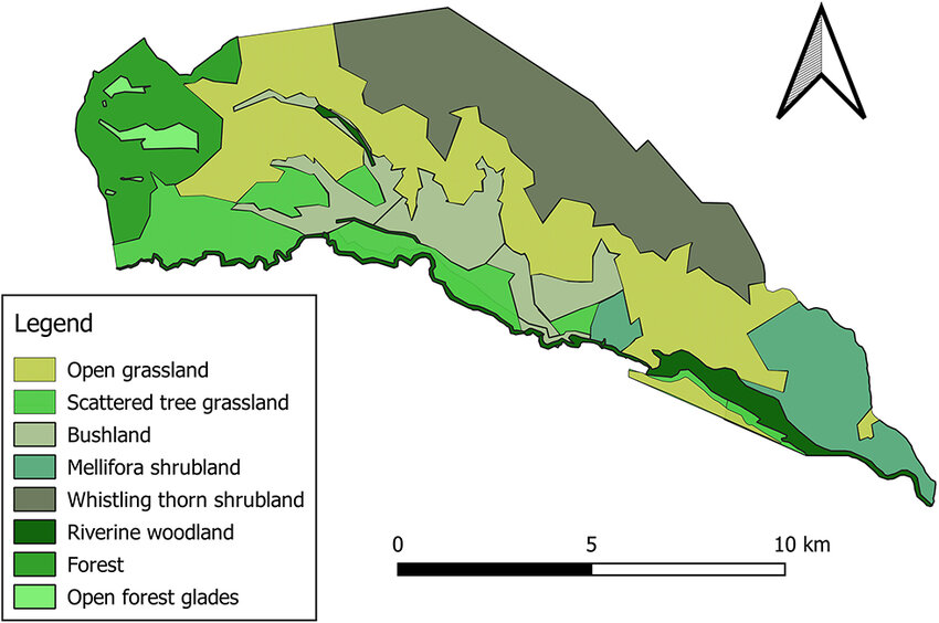
At a landscape scale, the park is best understood as a mosaic of five primary habitat systems that interlock and overlap:
- Open grasslands and grazing lawns that form the ecological core
- Acacia-dominated woodlands that support browsers, birds, and ambush predators
- Riverine forests associated with the Athi River and seasonal drainages
- Wetlands and dams that concentrate wildlife through the dry season
- Rocky gorges, kopjes, and valleys that create microhabitats, refuge, and raptor cliffs
This habitat diversity is driven by volcanic geology, variable soils, rainfall seasonality, fire and grazing dynamics, and conservation management. Nairobi National Park also functions as a critical ecological buffer for the metropolis by supporting ecosystem services such as water regulation, carbon storage in woody vegetation, and biodiversity conservation.
Geography and Location
- Where it is: Southern Nairobi County, immediately adjacent to the city on the northern side
- Key landscape feature: Open southern boundary that supports seasonal wildlife movements to and from Kitengela and the Athi-Kapiti ecosystem
- Altitude: About 1,533 to 1760 meters above sea level
- Climate: Temperate by Kenyan standards due to altitude, with two rainy seasons
- Rainfall: Often cited in the 800–1,200 mm annual range, varying by year and micro-area within the catchment
- Water backbone: The Athi River along the southern boundary plus seasonal streams and dams
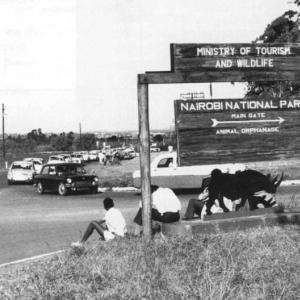
What makes it globally unique: It is the only protected area in the world located within a capital city, and its ecological health is closely tied to how well dispersal areas and corridors are maintained beyond the park.
This detailed guide delves into the park’s ecosystems, habitats, landscape features, and the intricate ecological interactions that sustain its biodiversity.
What makes it globally unique: It is the only protected area in the world located within a capital city, and its ecological health is closely tied to how well dispersal areas and corridors are maintained beyond the park.
🌾 NNP Grasslands Ecosystem
The Heart of Nairobi National Park
The grasslands cover the majority of Nairobi National Park and function as the main energy engine of the ecosystem. These plains are dominated by savanna grasses adapted to alternating wet growth pulses and dry-season stress.
Vegetation and Flora
According to the NNP 2020-2030 Management Plan the grassland coverage at Nairobi National Park is ~34 km² (about 76%) made up of scattered low–tall grassland: transitional form within broader plains
Key grass species commonly associated with the park’s savanna structure include:
- Red oat grass Themeda triandra: This grass is a dominant species in the park’s grasslands, characterized by its reddish-brown color, which gives the landscape a striking appearance, particularly in the dry season.
Best field cue: a reddish-brown hue in the dry season and distinctive seed heads after rains
Ecological role: builds tall-grass structure that supports nesting birds and provides stalking cover for predators - Pennisetum species including Pennisetum purpureum: Also known as elephant grass, this species provides vital fodder for herbivores such as zebras, buffalos, and eland.
Ecological role: high biomass fodder, especially important for larger herbivores - Eragrostis species
Ecological role: drought-tolerant ground cover supporting small fauna and seed-eating birds - Themeda triandra – red oat grass; dominant tall bunch grass in wetter phases
- Cynodon dactylon – forms short grazing lawns in high-use areas
- Sporobolus spp. – common in clay soils and depressions
- Chloris gayana – open plains rhizomatous grass
Across the plains you also see scattered shrubs and herbaceous plants that increase forage variety for browsers and mixed feeders.
Associated herbaceous layer may include:
- Indigofera spp. (nitrogen-fixing forbs)
- Tribulus terrestris (dry ground herb)
- Commelina spp. (moist patches)
How the grasslands stay grasslands: Grazing pressure and fire ecology limit woody encroachment. When grazing drops or fire is suppressed for long periods, shrubs and young trees can expand, changing visibility, forage composition, and predator hunting dynamics.
Ecological Function
- Primary forage base for zebra, wildebeest, buffalo, eland, gazelles
- Supports apex predators through herbivore biomass
- Maintained through grazing pressure and prescribed burning, both recognized in the KWS Management Plan as tools for maintaining grassland structure
Management Plan conservation target: Wooded grassland and open grassland vegetation extent and structure.
Wildlife in the Grasslands
Herbivores you can expect in grassland zones: zebra, wildebeest, giraffes, black rhinoceros, bushbucks, eland, impala, Thomson’s gazelle, and buffalo. These are the primary browsers in the woodland areas, feeding on acacia leaves and other shrubs.
What drives seasonal influx: During the rains, fresh grass growth can pull herbivores in from the Kitengela and Athi-Kapiti plains, reinforcing why the open southern interface matters.
Predators linked to the plains food web:
- Lions as apex predators, often using taller grass and slight terrain undulations for ambush
- Cheetahs using open sightlines to hunt smaller antelope where sprint space is available
- Spotted hyenas as both hunters and scavengers, commonly active around prey concentrations and water sources
Birdlife strongly associated with grasslands: ostrich and secretary bird, plus larks, lapwings, and widowbirds using tall grasses for nesting and cover.
Best quick answer to what the grasslands do: They are the primary grazing engine of the park and the foundation of the predator-prey system.
🌳 Acacia Woodland Ecosystem
Shelter for Browsers and Birds
Acacia-dominated woodlands appear as patches and belts across the park, often thickening near drainage lines and transitioning into riverine forest where water availability is more consistent. Woodlands provide shade, browse, nesting sites, and concealment.
Key Tree Species
- Acacia xanthophloea fever tree
Where it tends to be strongest: along watercourses and moister soils
Why it matters: critical browse for giraffe and structural habitat for many birds - Acacia drepanolobium whistling thorn
Where it thrives: drier zones and open woodland
Notable ecology: symbiosis with ants that live in swollen thorns and help defend the tree - Croton megalocarpus
Ecological value: shade, nesting structure, and microhabitat diversity - Acacia drepanolobium
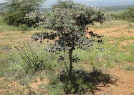
Acacia drepanolobium plant in nairobi national park
One of the most defining “in-between” habitats in Nairobi National Park is open dwarf tree grassland, especially the Acacia drepanolobium association, which is one of the largest vegetation blocks in the park by area (nearly 25 km²).
Ecologically, this habitat bridges open plains and denser woodland, creating:
- browse and edge-forage opportunities
- shade and thermal refuge
- concealment structure for ambush predators
- high nesting and perching availability for birds
Wildlife in the Woodlands
Browsers most associated with woodland structure: giraffe, black rhinoceros, bushbuck, and impala feeding on acacia leaves and shrubs.
Predator most associated with woodland cover: leopards, using trees and dense cover to approach prey such as bushbuck and impala, and sometimes using branches for resting and carcass storage.
Bird groups you often see using acacia canopy: hornbills, sunbirds, weavers, and woodpeckers.
Best quick answer for why woodlands matter: They are the browse-and-cover system that balances the open grassland exposure and supports high bird diversity.
🌳 Riverine Forest Ecosystem
A Biodiversity Hotspot Along the Athi River
Riverine forests concentrate along the Mbagathi River, Mokoiyet River, Athi River and seasonal watercourses. These zones are typically denser, more layered, and more stable in humidity than surrounding grasslands and open woodlands, creating a biodiversity hotspot effect.
Vegetation and Flora
Riverine forests support a multi-layered canopy including:
- Ficus sycomorus sycamore fig
Why it is important: a keystone food tree supporting baboons, monkeys, bushbuck, and many birds through fruiting periods - Olea africana wild olive
Adaptation: drought-tolerant riverbank tree providing shade and structure - Warburgia ugandensis Uganda greenheart
Noted for: medicinal associations and habitat value in riparian zones
Best quick answer to what riverine forest does: It regulates water flow, reduces erosion, and concentrates food and shelter diversity in a narrow corridor.
Wildlife in the Riverine Forests
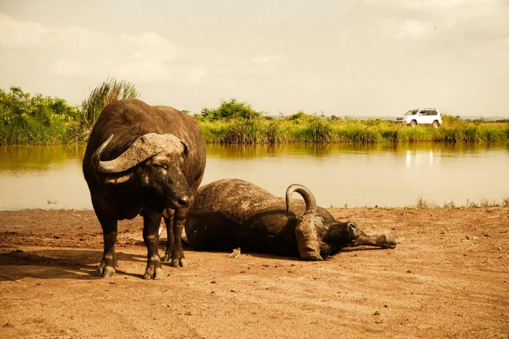
- Mammals: Buffalos, hippos, bushbucks, and waterbucks are frequently found in the riverine areas, taking advantage of the permanent water sources and abundant vegetation. The dense foliage also provides cover for more elusive species, such as leopards and genets.
- Reptiles: Nile crocodiles are common along the Athi River, preying on fish and other animals that come to drink at the river’s edge. Monitor lizards are also frequently seen basking on the riverbanks.
- Birdlife: Riverine forests are a birdwatcher’s paradise, home to species such as African fish eagles, kingfishers, great egrets, and hammerkops. Migratory birds often stop here during their long journeys between Africa and Europe, making the riverine forests an important habitat for both resident and migratory species.
💦 Wetland Ecosystem
Crucial Water Sources in a Seasonal Savanna
Nairobi National Park contains several wetlands and dams that act as dry-season lifelines. These include Hyena Dam, Athi Basin Dam, Nagolomon Dam, and seasonal swamps that expand and contract with rainfall and catchment runoff.
Vegetation and Flora at NNP
Wetlands are often dominated by:
- papyrus and sedges in marshy fringes
- bulrushes and other emergent plants
- patches of water lilies and floating vegetation where conditions allow
These plant communities provide cover, nesting platforms, and invertebrate-rich feeding areas for birds and amphibians.
Wildlife in the Wetlands
Aquatic Species: The wetlands are home to hippos, crocodiles, and numerous fish species. During the dry season, the wetlands serve as a vital water source for animals such as zebras, giraffes, and buffalos.
Birdlife: The wetlands attract large numbers of waterbirds, including pelicans, herons, ibises, and African jacanas. These birds rely on the wetlands for food, nesting sites, and protection from predators.Migratory birds can sharply increase diversity during certain seasons.
Amphibians and Reptiles: Frogs and toads are common in the wetland areas, contributing to the park’s diverse ecosystem. Terrapins and water snakes also inhabit the wetlands, preying on smaller aquatic species.
Best quick answer for why wetlands matter: They stabilize wildlife distribution through the dry season by anchoring water, food, and breeding habitat.
🪨 Rocky Gorges and Valleys
Shelters and Hunting Grounds Along Rugged Drainages
The southern sector includes rocky gorges and valleys, notably associated with the Mokoyeti River and rugged drainage features. These areas create microclimates and refuge zones distinct from open plains.
Vegetation and Flora
Rocky terrain supports hardy, drought-adapted vegetation including:
- euphorbias
- aloes
- small shrubs rooted in shallow, rocky soils
These plant communities stabilize slopes and provide perches and shelter pockets.
Wildlife in the Rocky Areas
- Klipspringers: These small antelope are well-adapted to the rocky terrain and are often seen leaping between the rocks in search of food.
- Hyraxes: Rock hyraxes are common in the gorges and use the rocky outcrops for shelter and protection from predators.
- Leopards: Leopards are known to inhabit the rocky areas, using the steep cliffs and valleys as hunting grounds where they ambush prey such as bushbucks and duikers.
- Birdlife: Raptors, including verreaux’s eagles and augur buzzards, nest in the cliffs and prey on small mammals and reptiles. The rocky terrain provides excellent perches for these birds to scan the landscape for prey.
Best quick answer for what rocky systems do: They create refuge, nesting cliffs, and predator advantage terrain that does not exist in open grassland.
🦁 Ecological Interactions and Conservation Importance
Nairobi National Park is not just a set of separate habitats; it is a connected system where energy, water, and wildlife movement bind everything together.
Food Web and Habitat Linkages
- Grasslands produce the bulk of forage biomass
- Woodlands and riverine forests diversify browse and shelter
- Wetlands stabilize dry-season survival and breeding cycles
- Rocky systems provide refuge, nesting cliffs, and hunting structure
A central interaction: Predator populations are sustained by grassland herbivore biomass, while woodland and riparian cover influences predation tactics and prey refuge.
Corridor Connectivity and Seasonal Movements
One of the most important ecological facts about the park: The open southern boundary allows seasonal movements between the park and the Athi-Kapiti ecosystem. This reduces internal overgrazing pressure, supports genetic exchange, and helps maintain ecosystem resilience.
Ecosystem Services to the City
Because the park sits beside Nairobi, it functions as an ecological buffer that contributes to:
- local climate moderation and green-space cooling
- biodiversity maintenance in an urbanized region
- carbon storage in woodland and riparian vegetation
- water regulation through wetlands and drainage stabilization
Conservation Management Context
Management under Kenya Wildlife Service focuses on protecting fragile habitats while balancing urban pressures. Core components commonly associated with this challenge include:
- anti-poaching patrols
- community outreach and coexistence measures
- tourism management and impact control
- habitat monitoring, especially in wetland and corridor-linked zones
Key conservation tension to understand: Corridor loss and habitat fragmentation increase ecological stress and human-wildlife conflict, particularly along the southern dispersal interface.
🧭 Soil, Vegetation Types, and Landscape Foundations
The park’s habitat pattern is strongly controlled by soil and drainage variation.
Soil Types You See Across the Mosaic
- Volcanic loam: often supports woodland and mixed shrub structure
- Black cotton clay: common in low plains; waterlogs in rains and cracks in dry season, shaping grass dominance
- Sandy alluvium: near channels and riverbanks, favoring riparian vegetation
- Localized saline or compacted patches: influence which grasses and herbs can persist
Best quick answer for why soils matter: Soils control water retention and nutrient availability, which directly determines vegetation structure and wildlife distribution.
Compa
Expert Habitat & Ecosystem Comparison of NNP vs Other Kenyan Parks and Reserves
| Park / Reserve | Approx. Size | Dominant Habitat Structure | Primary Ecological Driver | Landscape Scale | Hydrology Type | Key Ecological Identity | Core Conservation Tension |
|---|---|---|---|---|---|---|---|
| Nairobi National Park | 117 km² | Grassland–Acacia savanna–riverine mosaic | Southern dispersal connectivity + localized hydrology | Compressed, high edge-to-area | Rivers + dams | Urban-edge savanna mosaic | Corridor fragmentation & urban pressure |
| Masai Mara National Reserve | ~1,510 km² | Vast open savanna plains | Rainfall pulses + Great Migration | Large, contiguous plains | Major rivers (Mara, Talek) | Migration-driven predator–prey system | Land-use change in greater Mara ecosystem |
| Amboseli National Park | ~392 km² | Open plains + permanent swamps | Kilimanjaro aquifer-fed water table | Basin ecosystem | Subsurface aquifer-fed wetlands | Elephant–swamp ecological system | Water abstraction & basin hydrology shifts |
| Lake Nakuru National Park | ~188 km² | Alkaline lake + woodland | Lake salinity & nutrient cycling | Rift Valley basin | Soda lake hydrology | Flamingo-driven alkaline lake ecosystem | Water level fluctuation & catchment inflow changes |
| Tsavo National Park | ~22,000 km² (East + West) | Semi-arid scrub & thorn bush | Rainfall variability over vast area | Mega-landscape | Seasonal rivers (Galana, Tsavo) | Arid mega-rangeland | Infrastructure fragmentation & drought stress |
| Samburu National Reserve | ~165 km² | Semi-arid savanna + riverine corridor | Aridity gradient + Ewaso Ng’iro River | Medium-scale arid system | Permanent river corridor | Northern dryland specialist biome | River flow regulation & climate variability |
High-Level Ecological Interpretation
- Scale: Tsavo and Masai Mara operate at landscape or migration scale; Nairobi NP functions at compressed mosaic scale.
- Hydrology: Lake Nakuru is chemically driven; Amboseli is aquifer-driven; Samburu is river-driven; Nairobi NP relies on rivers, dams, and dispersal connectivity.
- Biodiversity Mechanism:
- Mara = migration biomass engine
- Amboseli = wetland refuge dynamics
- Nakuru = alkaline lake productivity
- Tsavo = large-scale arid rangeland processes
- Samburu = aridity-specialist adaptation
- Nairobi NP = corridor-dependent urban savanna resilience
Expert Bottom Line
Nairobi National Park is ecologically distinct not because it is the most biodiverse or largest, but because it is the most spatially constrained and boundary-sensitive savanna ecosystem in Kenya. Its long-term stability depends more heavily on corridor protection and habitat state balance than any of the larger, more contiguous wilderness systems.
✅ Conclusion: A Unique Urban Ecosystem
Nairobi National Park is a unique blend of wilderness and urban proximity, with its diverse ecosystems providing vital habitats for some of Kenya’s most iconic wildlife. Its grasslands, woodlands, wetlands, and riverine forests support a wide range of species, from large herbivores and predators to birds and reptiles.
- Wildlife lovers: Expect lions, rhinos, giraffes, buffalo, and hippos supported by diverse habitats.
- Birdwatchers: Over 500 recorded bird species are enabled by the habitat mosaic and seasonal wetland use.
- Conservation-minded visitors: The park’s future depends heavily on protecting dispersal connectivity and managing urban-edge pressures.
Nairobi National Park is not only a safari destination. It is a living ecological system whose resilience depends on habitat diversity, seasonal water dynamics, and corridor connectivity in the face of a rapidly expanding city.
1. Geography and Location
Nairobi National Park is situated in the southern part of Nairobi County, with its northern boundary adjacent to the rapidly expanding city of Nairobi. The park’s southern boundary is open and unfenced, allowing for the seasonal migration of wildlife to and from the Kitengela Plains and the Athi-Kapiti ecosystem. This open boundary is crucial for maintaining the ecological connectivity between the park and the surrounding landscapes.
- Altitude and Climate: The park sits at an elevation of 1,533 meters (5,030 feet) above sea level, with a temperate climate influenced by the high altitude. The average annual temperature ranges from 10°C to 25°C (50°F to 77°F), and the park receives 800–1,200 millimeters (31–47 inches) of rainfall annually, with two rainy seasons (March to May and October to December). The Athi River, which flows along the park’s southern boundary, provides a vital water source for the park’s ecosystem.
- Unique Urban Setting: The proximity to Nairobi city creates a striking contrast between the park’s wilderness and the urban skyline visible in the background. This juxtaposition makes Nairobi National Park one of the most unique wildlife reserves in the world, where visitors can observe lions, giraffes, and other large mammals with skyscrapers in the distance.
Stats:
- Covers 117 square kilometers (45 square miles)
- Altitude of 1,533 meters (5,030 feet) above sea level
- Receives 800–1,200 mm (31–47 inches) of rainfall annually
- Open southern boundary allows wildlife migration to the Athi-Kapiti ecosystem
2. Ecosystems and Habitats
Nairobi National Park is characterized by a variety of habitats, each supporting different species of flora and fauna. These habitats include open grasslands, woodlands, riverine forests, wetlands, and rocky gorges, creating a mosaic of ecosystems within the park.
a. Grasslands
The dominant habitat in Nairobi National Park is open grassland, which covers most of the park’s landscape. These grasslands are home to large herbivores such as zebras, wildebeests, eland, gazelles, and giraffes, which graze on the grasses that flourish during the rainy seasons. The grasslands also support predators like lions and cheetahs, which prey on the herbivores.
- Vegetation: The grasslands are dominated by species such as red oat grass (Themeda triandra), pennisetum, and Eragrostis species. These grasses provide both food and cover for herbivores, while also serving as nesting grounds for ground-dwelling birds like ostriches and secretary birds.
b. Woodlands
Patches of Acacia-dominated woodlands are scattered across the park, providing important habitats for species like impalas, bushbucks, and baboons. The woodlands also support a variety of bird species, including hornbills, sunbirds, and weaver birds, which nest in the trees.
- Key Tree Species: The woodlands are primarily composed of Acacia xanthophloea (fever tree), Acacia drepanolobium (whistling thorn), and Croton species. These trees provide shade and forage for browsers like giraffes and black rhinoceros.
c. Riverine Forests
The Athi River and other seasonal streams that flow through the park support riverine forests, which are lush and densely vegetated. These areas are critical habitats for wildlife, offering shade, water, and food. Species like hippos and crocodiles inhabit the river, while leopards, buffalos, and bushbucks frequent the surrounding forests.
- Vegetation: The riverine forests are dominated by trees like sycamore fig (Ficus sycomorus), wild olive (Olea africana), and warburgia species. The dense undergrowth in these areas provides cover for smaller mammals and birds.
d. Wetlands and Dams
Nairobi National Park is home to several artificial and natural wetlands, including Hyena Dam and Athi Dam, which play a crucial role in maintaining the park’s biodiversity. These wetlands support a rich variety of waterbirds, including African jacanas, herons, ibises, and pelicans.
- Wetland Species: Hippos and crocodiles are commonly found in these wetlands, along with aquatic birds. Migratory birds often use the park’s wetlands as a stopover during their long journeys, making it an important birding destination.
e. Rocky Valleys and Gorges
The southern part of the park features rocky valleys and gorges, particularly along the Mokoyeti River. These areas provide important refuge for animals like klipspringers, hyraxes, and leopards, which use the rocky outcrops for shelter and hunting.
- Flora and Fauna: Vegetation in these areas is sparse but includes species adapted to the rocky terrain, such as euphorbias and aloe plants. The rugged landscape also supports raptors like verreaux’s eagles and augur buzzards, which nest in the cliffs.
Nairobi National Park is best understood not as a single savanna, but as a five-system ecological mosaic: open grasslands, woody savanna, riverine woodland, forest patches, and wetland–drainage systems. Within these sit the nine mapped vegetation units identified in the 2020–2030 Management Plan, but functionally the park operates through these five interacting habitat engines.
The grasslands drive primary productivity and predator–prey dynamics. The woody savanna regulates browse, cover, and vegetation state transitions. Riverine systems anchor hydrology and concentrate biodiversity. Forest remnants add structural complexity and microclimatic buffering. Wetlands stabilize seasonal survival and spatial wildlife distribution.
Together, these systems form a hydrologically mediated, corridor-dependent savanna mosaic whose resilience depends on state balance, water integrity, and southern dispersal connectivity. With that framing in place, the following conclusions interpret the park not descriptively, but as a dynamic ecological system under active conservation management.
1. Open Grassland Systems
Includes:
- Grassland
- Scattered low–tall grassland
This is the primary grazing matrix and energy engine of the park. It drives herbivore biomass, predator dynamics, and seasonal movement patterns.
2. Woody Savanna Systems
Includes:
- Open dwarf tree grassland – Acacia drepanolobium association
- Open dwarf tree grassland – Acacia mellifera association
- Open low shrubland
These are structurally intermediate savanna states where grass and woody plants co-dominate. They regulate browse availability, predator concealment, and long-term vegetation transitions.
3. Riverine Woodland and Riparian Forest Systems
Includes:
- Open tall riverine woodland
- Riverine vegetation
Hydrologically anchored habitats along the Athi–Mbagathi system. These are biodiversity concentration corridors and dry-season refugia.
4. Forest Patches and Glade Systems
Includes:
- Forest glade
- Dense tall forest
Small but ecologically significant remnants that increase structural complexity, avian diversity, and microclimatic buffering.
5. Wetland and Drainage Systems
(Embedded across vegetation classes but functionally distinct)
Includes dams, marshes, and seasonally waterlogged depressions that regulate wildlife distribution and sustain aquatic productivity
That classification matters because Nairobi National Park’s biodiversity is not “high because it’s a park,” but because it is a compressed ecotone system—a small area that stacks multiple habitat energy pathways (grazing lawns, browse-based woody systems, aquatic production, rocky microhabitats) into a tight spatial footprint. In ecological terms, it behaves like a high edge-to-area landscape with disproportionately strong edge effects—good for beta diversity (habitat turnover), but fragile under fragmentation.
Conclusion 1: The park’s “engine” is grass–woody balance, not wildlife presence
A central management problem you can decipher from reading the 2020-2030 Management Plan is the state maintenance: keeping the system in the desired savanna states (open grassland + wooded grassland + shrubland mosaics) rather than allowing drift toward either (a) woody thickening in some zones or (b) degradation/soil exposure in others.
The management plan’s emphasis on defined vegetation units and habitat condition implicitly recognizes that herbivore biomass, fire regime, and rainfall variability jointly govern grassland structure and shrub/woodland encroachment.
In practice: if you lose grassland structure (composition + height heterogeneity + grazing lawn dynamics), you don’t just “lose a habitat”—you destabilize the whole trophic architecture that supports predator–prey dynamics.
Conclusion 2: Hydrology is the park’s stabilizer, and it is highly levered
In small savanna parks, water is not just a resource—it is a spatial organizer. Nairobi NP’s dams and river systems concentrate herbivores in the dry season, which then concentrates predation, disease risk, and vegetation pressure around water nodes. The management plan explicitly treats river systems and wetlands as conservation targets because they regulate ecosystem function well beyond their footprint.
The deep point: wetlands and riverine strips are keystone habitats in the strict sense—small in area, large in systemic effect. When wetland condition declines (sedimentation, invasive vegetation, altered inflows, pollution), the impact propagates into grazing distribution, browse pressure, and bird diversity across the entire mosaic.
Conclusion 3: Nairobi NP is ecologically “open,” and corridor integrity is the real carrying capacity
The park is fenced on three sides and open to the south, and that openness is not a trivia fact—it is the park’s population viability mechanism. The Athi–Kapiti / Kitengela interface enables seasonal movement, genetic exchange, and demographic rescue effects (reducing inbreeding and buffering prey base variation).
When that dispersal system is squeezed, you don’t simply “lose migration.” You create:
- genetic isolation risk (especially for wide-ranging species)
- prey base compression inside the park (amplifying grazing pressure and predator conflict)
- functional simplification (the system becomes less resilient to drought years)
Recent reporting highlights how corridor constriction can push the system toward what field ecologists describe as ecological extinction—populations persist briefly but lose long-term viability as connectivity collapses.
Conclusion 4: The park’s most underappreciated conservation asset is its botanical micro-endemism
Most visitors experience “savanna,” but the management plan draws attention to botanical exceptional resource values, including highly localized, seasonally wet rocky outcrops (notably near the Ivory Burning Site area) that support rare/restricted plants.
This is not ornamental botany—it’s a warning sign: microhabitats like these are the first to fail under edge disturbance, trampling, altered runoff, invasive species, or subtle hydrological change. Protecting them is a proxy for protecting the park’s fine-grained ecological integrity.
What NairobiPark.org is doing that actually maps to ecosystem stability
NairobiPark.org focuses on three leverage points for ecosystem-stability goals that align with the management plan’s logic:
- Corridor and dispersal advocacy (system-scale resilience)
By keeping public attention on the southern dispersal system—why it matters, what is being lost, and what solutions exist—NairobiPark.org supports the single biggest determinant of long-term viability: connectivity. - Management plan translation into public intelligence (operational accountability)
Taking management-plan concepts—vegetation units, habitat condition, wetlands as keystone systems, botanical exceptional sites—and translating them into clear, location-specific interpretation helps shift stakeholder conversation from “more tourism vs less tourism” to measurable ecological objectives grounded in the official planning framework. - High-specificity visitor education that reduces ecological noise (local impact control)
The strongest ecosystem outcomes often come from reducing cumulative minor pressures: off-track driving in sensitive soils, wetland edge disturbance, uncontrolled picnic impacts, and poorly understood “hotspot chasing” that concentrates vehicles in vulnerable nodes. A site that educates visitors on habitat function (not just species lists) directly supports the plan’s habitat-condition aims.
Bottom line
Nairobi National Park is best understood as a nine-habitat, corridor-dependent savanna system whose resilience comes from (i) maintaining grass–woody state balance, (ii) protecting keystone hydrological habitats, (iii) defending southern dispersal connectivity, and (iv) safeguarding botanically exceptional microhabitats.
At NairobiPark.org, we’ll keep anchoring our work in those leverage points—connectivity, plan-based accountability, and function-first education—as part of our goal not just to “promote the park,” through tours and safaris but to stabilize the ecosystem that makes the park viable.
From a field ecology and route-efficiency perspective, the number of ecosystems you can meaningfully interpret in Nairobi National Park depends less on distance and more on time spent stationary in habitat transitions, not just driving through them.
The park functions as a five-system mosaic:
- Open grassland
- Woody savanna (Acacia-dominated systems)
- Riverine woodland
- Wetlands and dams
- Rocky gorges and escarpments
Below is a realistic, expert assessment based on ecological coverage — not checklist tourism.
🕓 Half-Day Game Drive Safari (4–5 Hours)
Realistic Coverage: 2 to 3 Habitat Systems
A half-day drive typically allows for:
1. Open Grassland (Guaranteed)
This is unavoidable and forms the core viewing zone. Most predator-prey dynamics, rhino sightings, and plains herbivore activity occur here.
2. Woody Savanna (Very Likely)
You will pass through Acacia-dominated areas that allow interpretation of browse systems, giraffe feeding ecology, and leopard habitat structure.
3. One Water Node (Conditional)
If route planning prioritizes it, you can briefly cover:
- Hyena Dam
- Athi Basin Dam
or another wetland zone
However, time constraints limit deeper hydrological interpretation.
What You Usually Cannot Properly Cover in Half-Day
- Rocky gorge systems near Mokoyeti
- Elevated escarpment terrain
- Dense riverine woodland corridors in detail
- Botanical exceptional sites
A half-day drive offers broad ecosystem exposure, but not full structural understanding.
🕗 Full-Day Game Drive Safari (6–10 Hours)
Realistic Coverage: 4 to All 5 Habitat Systems
A full-day drive allows deliberate route design and slower ecological interpretation.
1. Open Grasslands (Core System)
Morning and late afternoon predator activity can be observed here under different light and temperature regimes.
2. Woody Savanna Zones
Extended time allows observation of:
- Browsing behavior
- Ant–acacia mutualism
- Vegetation structure gradients
3. Riverine Woodland
You can spend time along the Athi–Mbagathi drainage corridors, interpreting:
- Riparian canopy layering
- Bird concentrations
- Crocodile and water-edge ecology
4. Wetlands and Dams
Dry-season animal concentration patterns are best understood with time at multiple water bodies.
5. Rocky Gorges and Escarpment
A full-day itinerary can include southern rocky valleys and higher viewpoints, where:
- Klipspringers
- Hyrax colonies
- Raptor nesting cliffs
are ecologically explained, not just observed.
Expert Reality Check
- Half-day = ecological sampling
- Full-day = ecological systems understanding
A half-day safari shows you species within habitats.
A full-day safari allows you to understand how habitats regulate species.
From a conservation interpretation standpoint, only a full-day drive allows meaningful explanation of:
- Grass–woody state balance
- Water-mediated wildlife redistribution
- Corridor-dependent population resilience
- Microhabitat specialization
Bottom Line
If the goal is wildlife viewing only, a half-day drive is sufficient.
If the goal is to understand Nairobi National Park as a functioning savanna ecosystem, a full-day drive is the minimum format that allows all five habitat systems to be realistically experienced and interpreted in ecological context.