

A Nairobi National Park map does more than show where the roads go. It helps you understand how Nairobi National Park is arranged on the ground: where the gates sit, how the internal tracks connect, where the dams, rivers, picnic sites, and major landmarks are located, and how different sections of the park relate to wildlife viewing, route planning, and conservation. For most visitors, the real value of a Nairobi National map is not simply navigation. It is interpretation. A good map turns the park from a name on a booking page into a landscape you can understand before you arrive.

This guide explains how to read a Nairobi National Park map in practical terms, covering the main map features, what they mean on the ground, and how maps improve safari planning and ecological understanding. It brings together interactive, historical, ecological, zoning, and management maps to explain the park as both a visitor landscape and a protected ecological system. For readers focused specifically on entry points and access routes, see our separate Nairobi National Park gates guide.
This Nairobi National Park map guide is a supporting subtopic of the wider Nairobi National Park entity, because maps help explain the park’s location, internal structure, habitats, landmarks, access logic, and conservation layout in spatial form. For that reason, this page also complements our How to Visit Nairobi National Park guide, which covers the broader practical framework of planning a visit, while the maps guide helps readers visualize and interpret the park more clearly before arrival.
Interactive Nairobi National Park map
To make this guide more useful for real trip planning, we include an interactive Nairobi National Park map developed in-house by NairobiPark.org. This map is intended as a practical visitor resource. It helps readers visualize the park spatially before arrival, understand where key features sit in relation to one another, and interpret how roads, gates, landmarks, and safari areas connect on the ground. Its value is not only in showing location, but in helping visitors translate park geography into route logic.
We also include an additional interactive Nairobi National Park map adapted from Tracks4Africa.co.za, which provides another practical spatial reference point. Used together, the NairobiPark.org map and the Tracks4Africa-based map help readers approach the park from two complementary directions: one oriented toward interpretation and visitor understanding, and the other toward broader travel geography and navigational context.
Some of the maps included in this guide are also direct screenshots or extracts from research materials and expert planning documents, especially conservation and management references.
These include material derived from expert reports and from the Nairobi National Park Management Plan 2020–2030, which remains one of the most important documents for understanding how the park is structured, managed, zoned, and interpreted at landscape scale.
That matters because not every map in this guide is meant for basic wayfinding. Some are included because they explain ecological function, management priorities, habitat pattern, or spatial conservation pressure more clearly than ordinary text can.
What a Nairobi National Park map shows
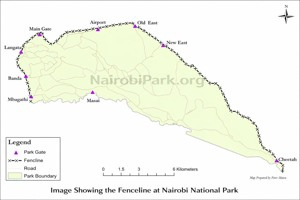
A Nairobi National Park map usually shows far more than the park boundary. Depending on the version, it may include the entrance gates, internal roads, dams, rivers, picnic sites, major landmarks, habitat zones, staff and operations areas, wildlife-use areas, fencing, dispersal areas, and migration routes. Some maps are designed mainly for visitors. Others are designed to explain management, ecology, or conservation pressure.
That distinction matters. A tourist map is built to help you move through the park. A management or ecological map is built to help you understand how the park functions.
Why a Nairobi National map matters for visitors
A Nairobi NP map is useful because Nairobi National Park is compact enough to feel legible, but complex enough that first-time visitors can still misunderstand how it works. The park is not simply one open block of safari country. It is a structured landscape with gates, loops, dead ends, wetlands, open grassland, riverine areas, fenced edges, restricted sections, and different intensities of visitor use.

Reading the map properly helps you understand four practical things before a visit.
First, it shows how the park sits relative to Nairobi. This matters when deciding which gate is most practical.

Second, it shows how the internal road network works. This helps you understand why some game drives feel efficient while others become repetitive or poorly sequenced.

Third, it shows where key habitats and landmarks are located. That improves your ability to interpret sightings rather than treating the park as a random wildlife loop.
Fourth, it reveals that Nairobi National Park is also a conservation landscape. A map can show its fencing, zoning, migratory interface, and ecological pressures in a way that ordinary travel writing cannot.
Nairobi National Park map: location and setting
The first thing a Nairobi National Park map should help you understand is location. Nairobi National Park lies immediately south of Nairobi and forms one of the most unusual urban-edge protected areas in Africa. On the map, this relationship is striking. The park sits against the metropolitan edge of Nairobi, yet still opens southward into the broader Athi-Kapiti-Kitengela dispersal system.
That spatial relationship is one of the most important facts about the park. It explains why the skyline appears in photographs, why gate choice matters for visitors coming from different parts of Nairobi, and why the southern dispersal area is so important to the park’s ecological function.
How to read a Nairobi National Park map for safari planning
If you are using a Nairobi National Park map for visit planning, focus on five features first: the gates, the road network, the water features, the landmarks, and the park edge.
1. Gates
A map helps clarify where the main public access points are and how they relate to your arrival direction. This matters because travel time to the park can vary substantially depending on whether you are coming from central Nairobi, Wilson Airport, JKIA, Karen, Lang’ata, or the Mombasa Road side.
2. Internal roads and tracks
A Nairobi National Park map helps you understand how the game drive tracks connect the park’s habitats and landmarks. Some sections are better suited to shorter drives, while others make more sense only if you have enough time to loop through broader sections of the park.

3. Rivers, dams, and water pans
Water features often structure both habitat and visitor movement. On the map, these are not just scenic labels. They help explain why certain parts of the park attract birdlife, why some areas hold wildlife differently in dry and wet conditions, and why some stops become natural route anchors.
4. Landmarks and visitor sites
A Nairobi National Park map often marks major visitor landmarks such as picnic sites, the Ivory Burning Site, viewpoints, and other recognizable nodes. These help give a safari route shape and make the park easier to understand in narrative rather than abstract terms.
5. Boundary and edge conditions
A strong Nairobi National Park map also shows the boundary clearly. This matters because the park is not ecologically isolated. Its edge condition is part of its story. Fencing, dispersal pressure, and adjacent urban or peri-urban development all influence how the park functions.
Different types of Nairobi National Park maps
Not every Nairobi National Park map serves the same purpose. The most useful way to understand them is by type.
Visitor map
A visitor-focused Nairobi National Park map is designed for orientation. It usually shows gates, main roads, picnic sites, landmarks, and general park layout. This is the most useful map for someone planning a game drive, choosing a route, or trying to understand where the key visitor areas are.
Road network and safari route map
This type of Nairobi National Park map focuses on internal movement. It shows how roads, tracks, and junctions connect different parts of the park. It is especially useful for route logic, helping visitors or guides avoid inefficient backtracking and better sequence a drive through different habitats.

Gates map
A gates-focused Nairobi National Park map highlights active and closed access points and places them in context. This is particularly useful because gate choice can affect travel time, convenience, and the structure of the day, especially for airport transfers or short safaris.
Zoning map
A zoning Nairobi National Park map shows how the park is divided for management purposes. These maps may identify high-use zones, low-use zones, development zones, special-use areas, restricted zones, and other management sectors. They are valuable because they explain that visitor access is only one layer of the park’s identity. The park is also managed as an ecological and administrative system.

Vegetation and habitat map
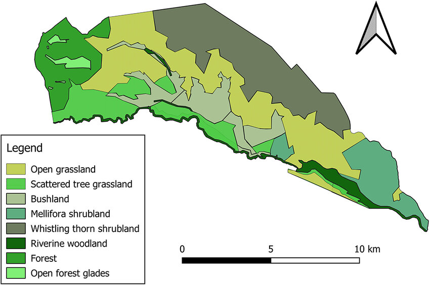
A vegetation-focused Nairobi National Park map shows the distribution of grassland, woodland, riverine habitat, glades, and other vegetation types. This matters because wildlife viewing in Nairobi National Park is partly habitat reading. A map of vegetation helps connect sightings to ecology.

Land cover map
A land cover Nairobi National Park map usually broadens the picture further by showing the park in relation to surrounding landscape patterns. This is especially useful for understanding fragmentation, urban pressure, and ecological context beyond the fenced or gazetted area itself.

NNP Wildlife distribution map – Rhinos and Lions
Some Nairobi National Park maps focus on rhino distribution, lion movement, or other species-specific patterns. These are interpretive rather than navigational. They help explain how animals use space, how monitoring works, and how species distribution reflects habitat and conservation management.


Migration and dispersal map
This is one of the most important conservation-oriented Nairobi National Park map types. It shows how the park relates to the larger Athi-Kapiti and Kitengela dispersal system. These maps are essential for understanding that Nairobi National Park cannot be interpreted only within its fence line. Its ecological life depends partly on processes that extend beyond the formal park boundary.


Historical map
A historical Nairobi National Park map shows how the park was understood in earlier periods. These maps are useful not only as visual artifacts but also as records of how the park’s identity changed over time.
Historical evolution of the Nairobi National Park map
When you compare older and newer Nairobi National Park maps, what emerges is not just a change in graphic style. It is a change in how the park itself was seen and used.
Early map period: the Royal Nairobi National Park era
A comprehensive account of Nairobi National Park maps requires looking beyond a single modern tourist map and tracing how the park has been represented over time. The cartographic record shows a clear progression: from the 1950 colonial-era map produced only four years after gazettement, to the more technical Survey of Kenya mapping of the 1970s, and later to the more visitor-oriented illustrated maps that appeared by the 1990s.
What this progression reveals is not only a change in graphic style, but also a change in how Nairobi National Park itself was understood. Earlier maps present the park largely as a newly established protected area on the edge of Nairobi, while later maps show a more operational, surveyed, and visitor-interpreted landscape.
The 1950 Dennis Owen Mathews map, published in London as Map of the Royal Nairobi National Park and Environs, reflects Nairobi National Park in its early phase. The park had been gazetted in 1946 under the leadership of Mervyn Cowie, and at that stage it was still a relatively new conservation project on the edge of a much smaller Nairobi. The map gives the area as 46 square miles and uses a scale of 1:50,000.
They tend to emphasize broad area definition and general setting more than fine operational detail. In that sense, they are as much historical documents as navigation tools.

Survey-era operational maps
Later survey-based Nairobi National Park maps show a major shift toward functional precision. Scale becomes tighter, contouring and spot heights appear, rivers are differentiated more carefully, road classes become clearer, and internal junctions are numbered. These are the first maps that treat the park not simply as a protected space, but as an operationally legible landscape.

This transition matters. It marks the point where the park becomes more than symbolic on paper. It becomes manageable, navigable, and structured.
Modern and late-20th-century visitor maps
Later Nairobi National Park maps begin to show more recognizable visitor landmarks and interpretive points. These maps are often easier for general readers because they connect physical space with safari experience. Landmarks such as the Ivory Burning Site begin to anchor the map not only geographically but narratively.

Nairobi National Park map and conservation understanding
A Nairobi National Park map is also one of the best tools for explaining why the park matters ecologically. Maps can show conservation reality with a level of clarity that ordinary description often cannot.
A fencing map shows where hard boundaries shape movement and management. A zoning map shows how different internal sectors are managed differently. A lion movement map shows that predator use of the park is spatially patterned rather than random. A rhino distribution map shows where one of the park’s most important conservation functions is concentrated. A migration or dispersal map shows that the park’s ecological story extends beyond the official boundary.
This is why a Nairobi National Park map should not be treated only as a tourist aid. It is also an interpretive framework for understanding one of Africa’s most unusual protected areas.
Nairobi National Park map and wildlife viewing
A good Nairobi National Park map can improve wildlife viewing by helping you read habitats more intelligently. Open grassland, wooded sections, river corridors, wetland edges, and dam zones do not all offer the same viewing conditions. Even without predicting exact sightings, a map helps you understand why certain species or safari experiences are more associated with some parts of the park than others.
This is particularly useful in Nairobi National Park because the park is compact enough that route planning has a real effect on the shape of the safari. A visitor who understands the map is better prepared to interpret the drive as a sequence through habitats, not just a search for random sightings.
What to look for in the best Nairobi National Park map
The best Nairobi National Park map is not necessarily the one with the most labels. It is the one that makes the park easiest to understand. In practice, that means the map should show:
- the park boundary clearly
- the main gates and access logic
- the internal road network
- major landmarks and visitor sites
- rivers, dams, and water features
- habitat or vegetation pattern where relevant
- conservation context where possible
- enough spatial clarity to relate safari movement to the park’s structure
A strong map helps a visitor do two things at once: navigate and interpret.
Common mistakes when using a Nairobi National Park map
One common mistake is assuming all maps are meant for direct route navigation. Some are not. Some are ecological or management maps and should be read as interpretive tools.
Another mistake is treating the park as if its visible roads tell the whole story. In reality, a Nairobi National Park map often makes sense only when read together with ecological context, visitor access rules, and the park’s relationship to the wider southern dispersal landscape.
A third mistake is using the map only to find where things are, rather than to understand why they are there. The best use of a Nairobi National Park map is explanatory, not merely directional.
Is a Nairobi National Park map only useful for self-drive visitors?
No. Even visitors on guided safaris benefit from understanding a Nairobi National Park map. In fact, guided visitors often gain more from it because the map helps them follow the logic of the drive, understand where they are within the wider park, and better interpret how roads, habitats, landmarks, and wildlife zones fit together.
For first-time visitors, this can be the difference between feeling taken through a series of disconnected stops and feeling that they have actually understood the park.
Final answer: what a Nairobi National Park map really helps you do
A Nairobi National Park map helps you do far more than find direction. It helps you understand the park as a structured landscape shaped by roads, habitats, landmarks, conservation zones, wildlife-use patterns, and urban-edge geography. It is both a planning tool and an interpretive tool. Used well, it improves route logic, sharpens visitor understanding, and reveals why Nairobi National Park is not just easy to visit, but unusually important to understand.


